The Elevated Mixed Layer
Jonathan
D. Finch
hugehail@yahoo.com
Links
Main
Page
Convective
Outlooks
Special
Cases for the United States
Bengal
Tornadoes--background information
Historical
Tornado Tracks for East India and Bangladesh
Meteorological
Charts for Historical Tornado Cases for Bengal
Latitudinal
Comparison of the Geostrophic Wind Approximation
Assessing
Instability on the Front Range Without Upper Air Data
Potential
Temperature and Mixing Ratio--Contributions to CAPE on Elevated Terrain
The
elevated
mixed layer (EML) was first discussed
in pioneering work by Dr. Toby Carlson in the mid to late 1960s. Carlson
did
additional work on the EML in the 1980s. He noted that the EML results
in a "lid" which prevents thunderstorm activity. His
synoptic
meteorology book entitled "Mid-latitude Weather Systems" has a chapter
devoted to the "lid". This book is a must read for
meteorology
students and forecasters. Most meteorology textbooks are highly theoretical
and are frankly no fun to read. Carlson's
book
actually reads like a book and is interesting throughout. I was fortunate
enough to enjoy Carlson's advanced synoptic
meteorology
course while attending Penn State University in 1991-92. While many of
the courses I took in graduate school were
just
about deriving equations, this course was very applied and I learned a
lot. Yes, we learned the components of the important
equations
and applied the equations to practical problems, but the whole course
was not based on proving one's mathematical
prowess.
The EML is important for the following reasons:
1.
The EML prevents deep, moist convection until high instability is achieved.
In the absence of deep, moist convection,
warm, moist air can flow poleward in an unimpeded manner. Daily evapo-transpiration
also adds moisture
to the boundary layer further enhancing theta-e.
2.
The EML tends to keep storms isolated. When deep moist convection
occurs in a capped environment, it tends to be in
localized areas of enhanced convergence such as along out flow boundaries,
dryline and terrain features, or of course along
frontal boundaries. Isolated storms tend to be more severe than widespread
storms since there is less competition for available
warmth and moisture.
3.
The EML along the southern edge of the westerlies prevents deep vertical
mixing. Deep vertical mixing is a CAPE
destroyer. It is very difficult to maintain high mixing ratios when very
deep mixing is occurring. The cap provided by the EML
confines the moisture to a shallow layer, preventing the mix-out effect.
This effect is most apparent in late-spring and summer
when the southern edge of the westerlies retreats to 40-45N. The high dewpoints
will usually be along the southern edge of the
westerlies where the lid is the strongest and where cold fronts stall out.
Moisture convergence is also greatest along the southern
edge of westerlies, typically just poleward of stalled out fronts or outflow
boundaries where evapo-transpiration is at a maximum
from vegetation and previous rains. The mixout effect can also occur beneath
the strong capping inversion in cases where moisture
return is extremely shallow, particularly when strong synoptic-scale disturbances
are involved.
EMLs develop when arid regions
heat up and deep, dry adiabatic lapse rates extend from the surface to
between 450mb and 600mb.
Read more about elevated heating and its contribution to instability on the high plains here. EMLs
can occur any time of the
year. Of course an EML can occur along with a
very stable boundary layer too. But this page is
devoted
to EMLs that result in
capping inversions above a warm and moist boundary
layer. I have found EML soundings in all seasons
and all areas east of the
Rockies. EMLs are slow to modify after leaving
their source region since lift and subsidence have little
effect on dry-adiabatic layers.
The EML can be carried well downstream
without changing character much at all.
In general, the surface dryline
marks the southwestern edge of the EML in the Great Plains. To the east
of the surface dryline, the
moist layer is capped by
the EML. To the west of the dryline, the mixed layer extends all the way
to the ground and is not "elevated".
In general, the capping
inversion increases as one progresses east, away from the surface dryline. Near the dryline at peak heating,
convective inhibition tends
toward zero, but convergence must still be present on the mesoscale to
develop a storm. If storms do
not develop on the dryline, do
not assume that the dryline is "capped". This explains the
laminar look to the lower part of supercell
storms that have progressed into
the capped region east of the dryline. Storms that move rapidly into a
capped region may die before
becoming a supercell. Keep
in mind that just because there is convective inhibition out ahead of
the dryline, does not mean that storms
cannot survive in this region.
Once storms develop into high based supercells in the strongly heated
air near the dryline, the storms
tend to maintain themselves after
moving into the "capped" but more moist environment to the east.
So forecasters should not be
fooled by point model soundings 50 miles east of the surface dryline that
show a capping inversion. Of
course the moist layer is
capped at locations east of the dryline. This should be no surprise. This
does not mean that storms will not
develop along the dryline
with intense daytime heating on elevated terrain.
If the EML did not exist,
then the Plains severe storm environment would be entirely different. For
one, there would be
no dryline.
For the EML not to exist,
one would have to remove the Rockies and desert southwest. Then of course
you
wouldn't get a lee trough.
So like the dryline, the
EML is an integral part of the Plains' severe storm environment.
The EML is a basic concept that must be
understood and appreciated
by forecasters.
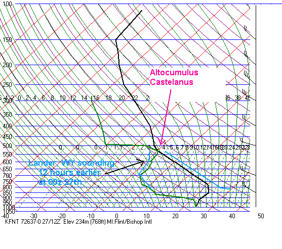
Oftentimes you will see a
saturated or nearly saturated layer at the top of the EML. In my opinion,
this is where altocumulus castelanus
is found. This can be illustrated using the August 27, 1973 sounding
and surface
obs from Flint, MI. So where did the elevated mixed
layer originate from? To answer this question, think of
what the vertical potential temperature and mixing ratio profiles
looked like in the
EML source region. The sounding from Lander, WY 12
hours earlier was overlaid on the Flint sounding. Note that the thermal
and
moisture profiles are very similar. The moisture at
525mb in the Flint sounding originated in the boundary layer over the
Rockies.
Granted, it may have taken longer than 12 hours
for the EML to advect from the northern Rockies to Michigan. With
afternoon heating
over the Rockpile, relative humidity will tend to
increase with height. There is often a saturated or nearly saturated
layer at the top of a
deep, mixed boundary layer. So mixing can
redistribute the moisture profile to such an extent that
saturation occurs. During summer when
mixing depth is greater, this moist layer can be as high as 450mb.
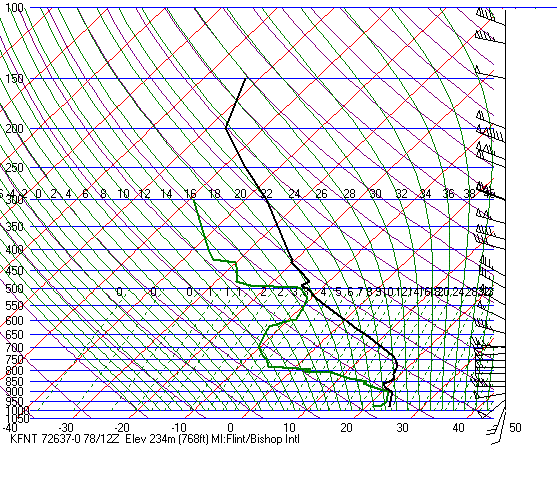
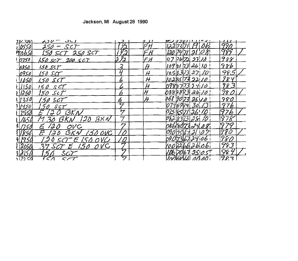
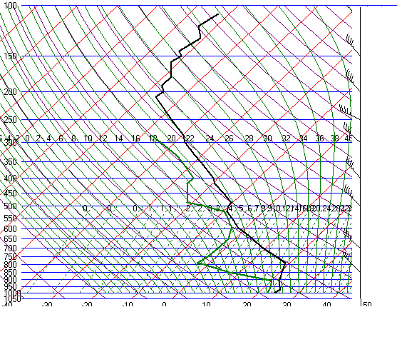
On August 28, 1990(day of the F5 Plainfield tornado), the Flint sounding showed an elevated mixed layer. Although the observation
forms from Flint were not available, the observations from Jackson, MI showed mid cloud that was likely accas.
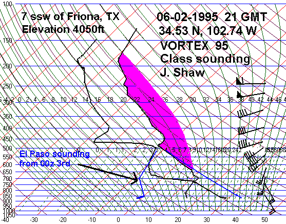
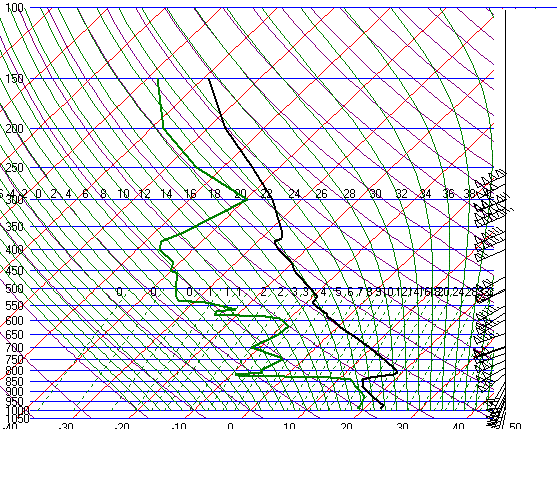
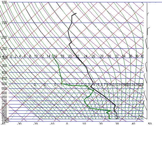
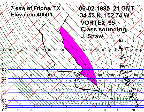
This vortex sounding taken by vortex near Friona on June 2, 1995 at 21 UTC shows an EML with a nearly saturated layer from
480 to 500mb. Overlaid is the El
Paso sounding from nearly the same time. El Paso is roughly upstream
from Friona.
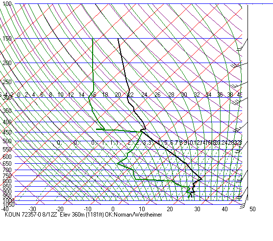
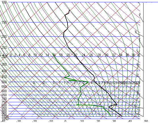
The 12 UTC June 8, 1995
sounding showed a well developed EML from possibly 2 different source
regions. Accas was present
over Oklahoma based on the surface observations that showed a scattered to broken cloud deck around 18000ft.
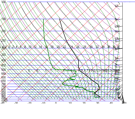
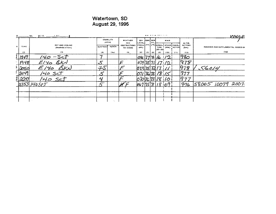
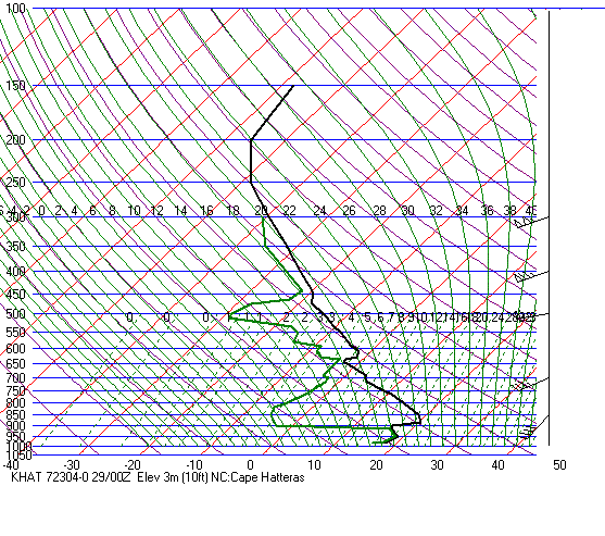
The 00 UTC August 30 1995 sounding from Aberdeen, SD showed an EML with the top around 500mb. The surface obsertvations
from Watertown show a scattered
to broken cloud deck at mid levels which was probably accas.
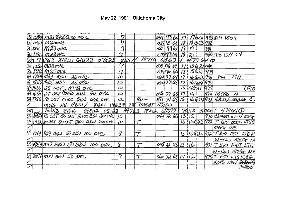
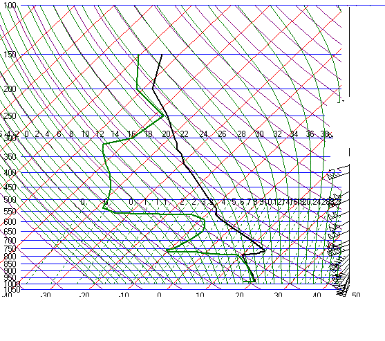
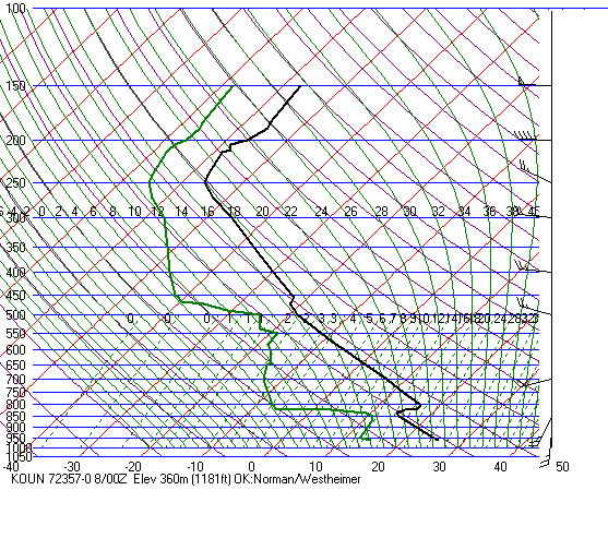
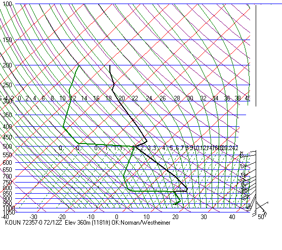
On May 22, 1981(day of the famous Cordell tornado) the 00z sounding from OKC showed a well formed elevated mixed layer
and the surface observations showed ACCAS at about the same time.
Some
EML sources include:
1.
Dry, elevated terrain of the interior, western United States
2.
High plains of the United States
3.
Sierra Madre Occidental of Old Mexico
3.
Western desert areas of southern Africa
4.
Desert areas of northern India
5.
Parts of Spain
6.
Saharan north Africa
In
the cool season, the EML (with positive instability) can occur over the
southern United States. Nothern old Mexico
and
the southern Rockies are the source region this time of year.
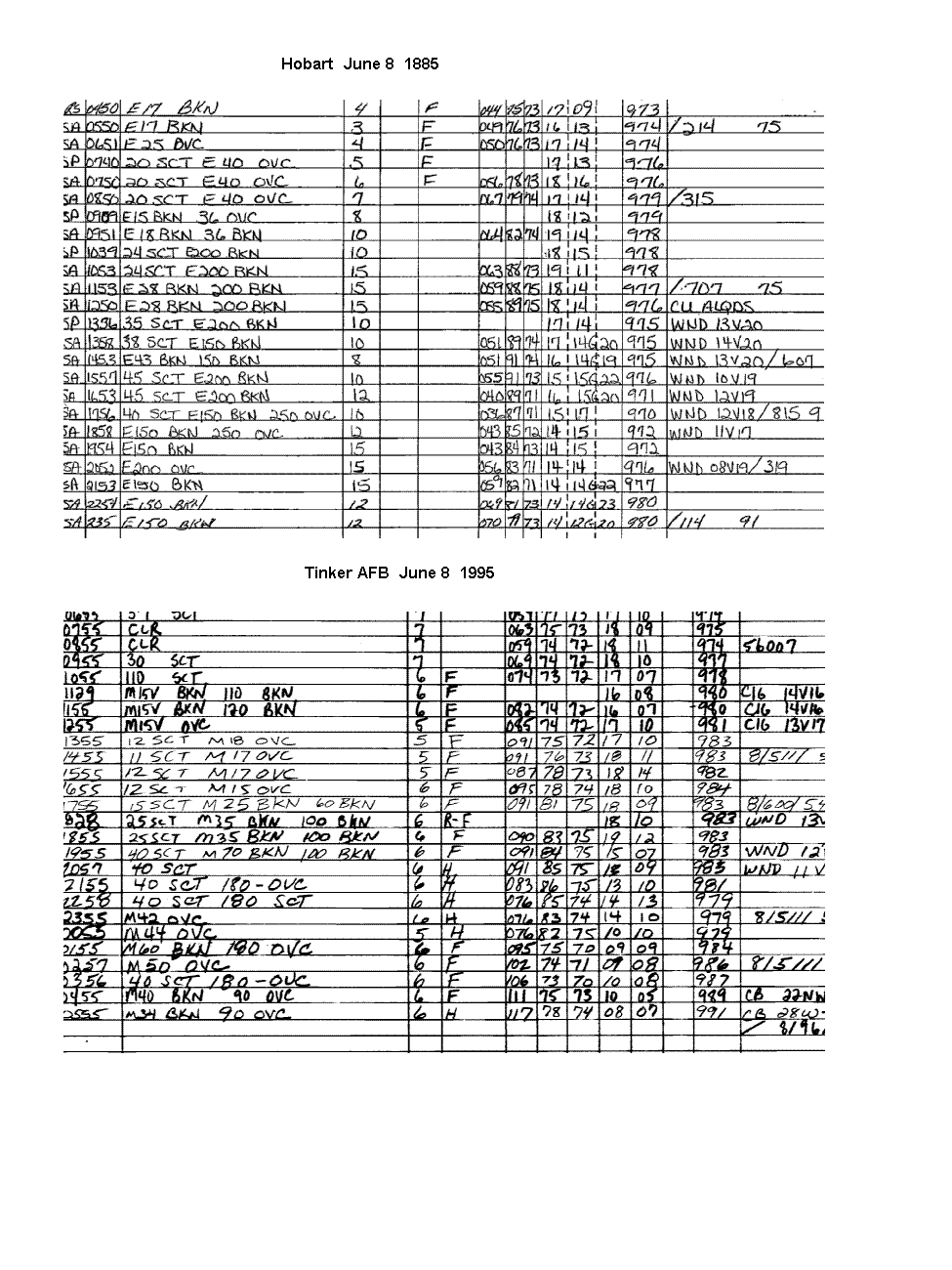
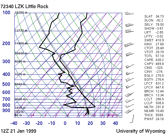
Little
Rock (Nov 27, 1994) Tornado
outbreak in eastern Arkansas and western Tennessee
Longview,
TX (Nov 27, 1994)
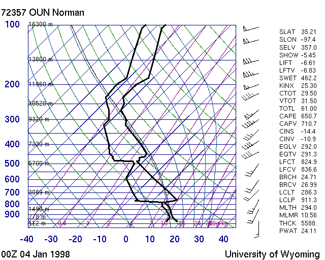
Norman,
OK (Jan 3, 1998) Numerous large hail reports across
Oklahoma and Texas
Little
Rock (Jan 21, 1999) Tornado outbreak in Arkansas and
adjacent states
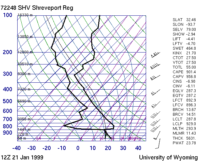
Shreveport
(Jan 21, 1999)
The EML can be found from
time to time along the east Coast. Here are a few notable examples from
prominent tornado
cases:
These EMLs originated from the high plains and Rockies.
Albany(
Aug 28, 1973) F4 killer tornado in Columbia county,
NY and Berkshire county, MA
Washington
Dulles (Aug 28, 1973)
Washington
Dulles (July 10, 1989) Tornado family moved SSE from Montgomery
county, NY to New Haven,
CT to eastern Long Island. Near baseball sized hail(2.5") fell on
eastern
Long Island
Another tornado family moved SE across northern New Jersey.
Hatteras
(Mar 28, 1984) At least 2 tornadic supercells, one
of which produced many tornadoes over a 5 hour period.
57 people killed
Here
are some additional EML soundings from the United States:
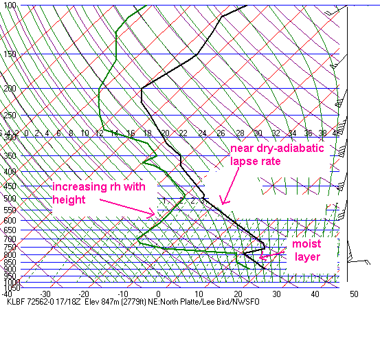
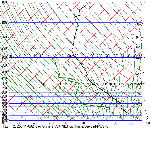
North
Platte (July 10, 1977) F3 tornado in Cherry county, NE and
Bennett county, SD
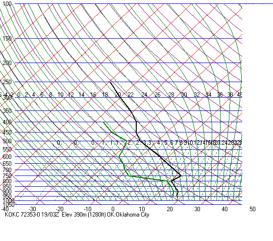
Oklahoma City (May 22, 1981) Tornado outbreak in Oklahoma and famous Cordell tornado
Flint
(Aug 28, 1990) Plainfield F5 tornado
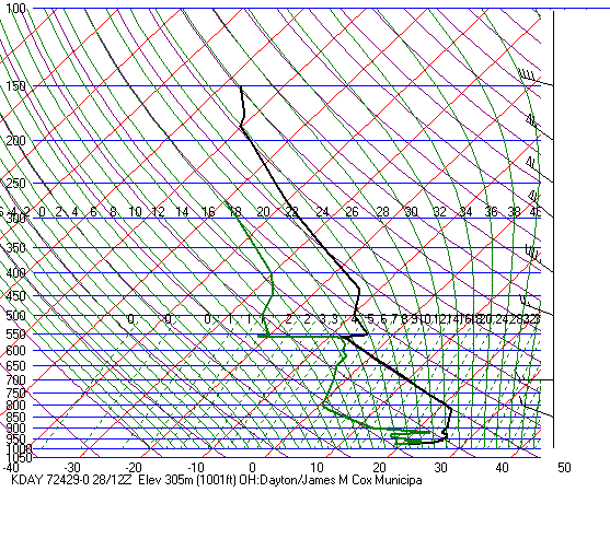
Dayton
(Aug 28, 1990)
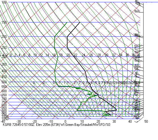
Green
Bay (Sep 6, 1995) F2 tornado Rice county, MN
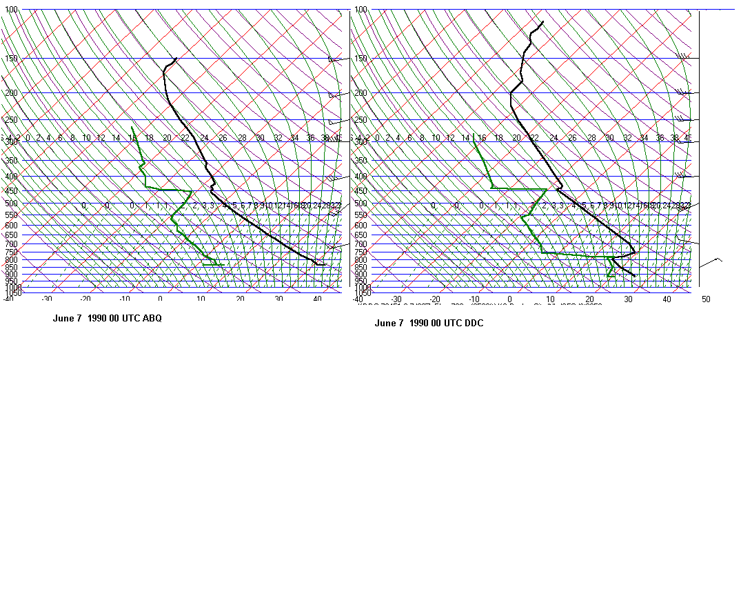
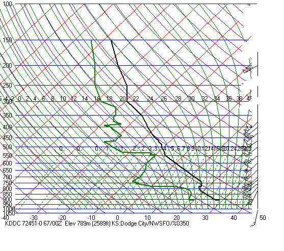
Dodge
City (June 6, 1990) Limon, CO tornadoes
Friona,
TX (June 2, 1995) Large tornadoes near Dimmit and Friona,
TX
Amarillo,
TX (Mar 19, 1982) Long-track F4 tornado TX, OK panhandles
North
Platte (May 17, 2000) Large tornado at Brady, NE
Dodge
City (May 16, 1995) Tornadoes in western Kansas
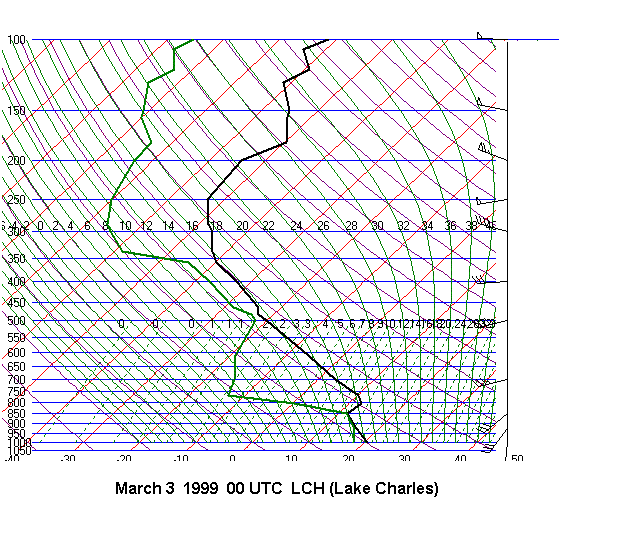
Lake
Charles (Mar 2, 1999) Tornado kills 1 person north
of Lake Charles, LA
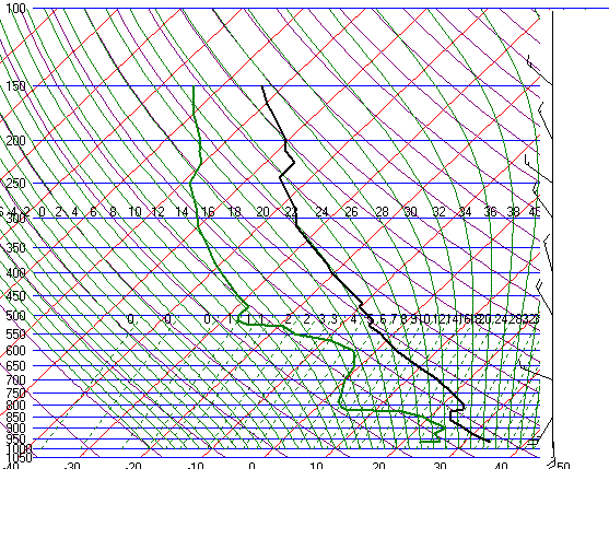
Norman,
OK (Apr 7, 1995)
Norman,
OK (Jul 26, 1995) Large hail in Oklahoma. Large tornado
the day before SE of Dodge City
Aberdeen,
SD (Aug 29, 1995)
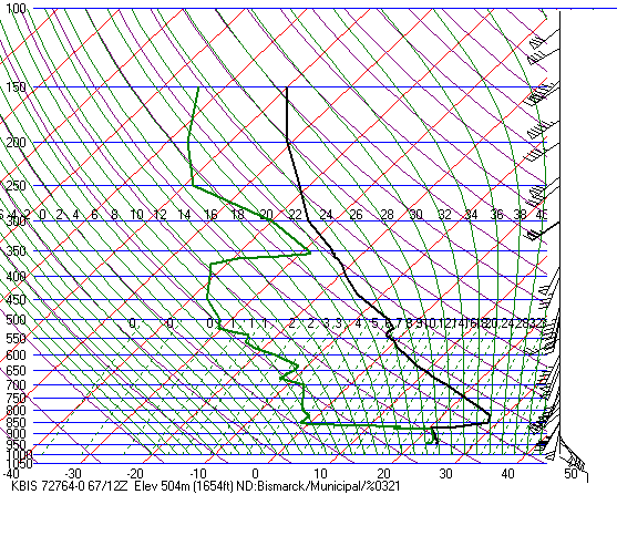
Bismark,
ND (Aug 17, 1995) Several 4 inch hail reports in North Dakota
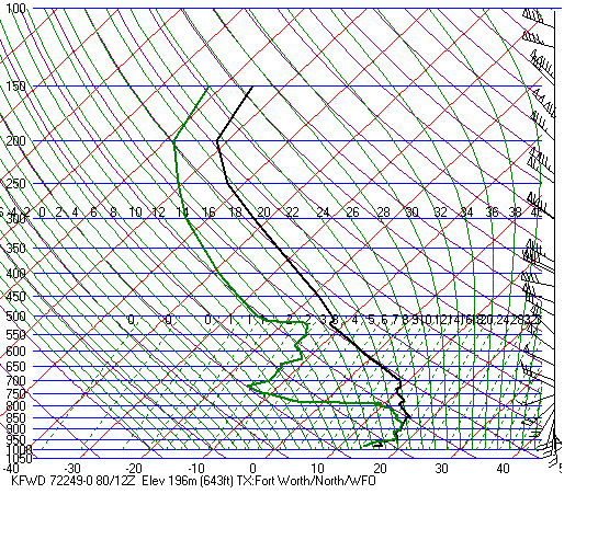
Fort
Worth (Apr 30, 1995) Large hail reports across Texas
and Oklahoma
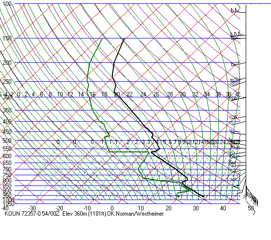
Norman,
OK (June 8, 1995) Large tornadoes in TX panhandle
Norman,
OK (Oct 3, 1994) Large hail in Colorado, TX and OK
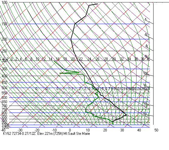
Sault
Saint Marie, MI (Aug 27, 1973) Tornadoes the next day
in NY and MA
Flint,
MI (Aug 27, 1973)
Huron,
SD (July 04, 1978) Killer tornadoes in in North Dakota and
northern MN
Oklahoma
City (Mar 19, 1948) Tornado outbreak from OK to IL with many
fatalities
Norman(April
22, 2004) Tornadoes in northeast Oklahoma
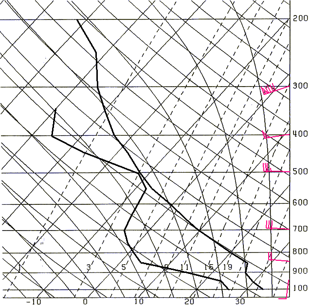
Even in the hot, dog days
of summer, the EML can be found. Here is an example from Topeka,
KS from August 6, 1962. An
F4 tornado hit not far from
Topeka at 530 pm. The source region was likely the high plains since the
top was 620mb. This is
one of the most unstable
soundings I have ever seen.
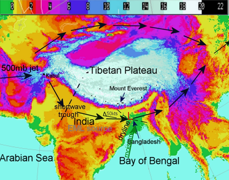
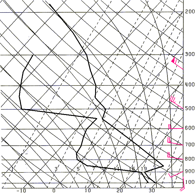
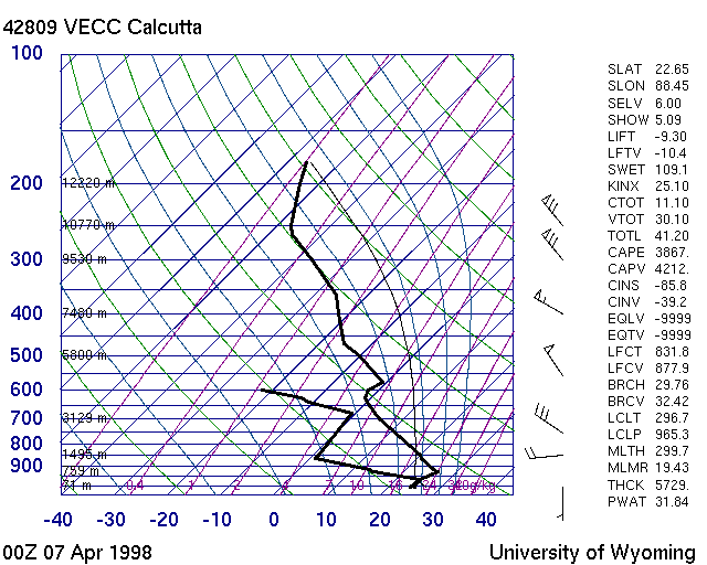
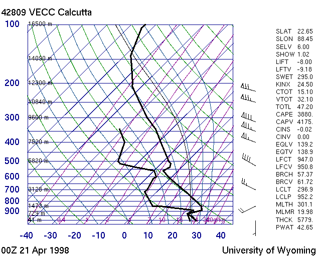
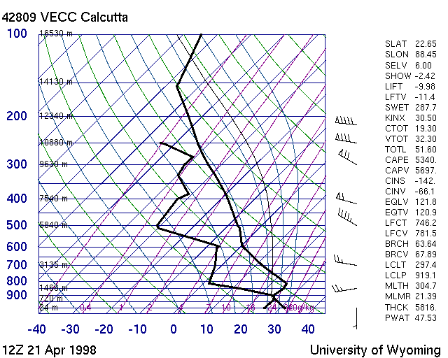
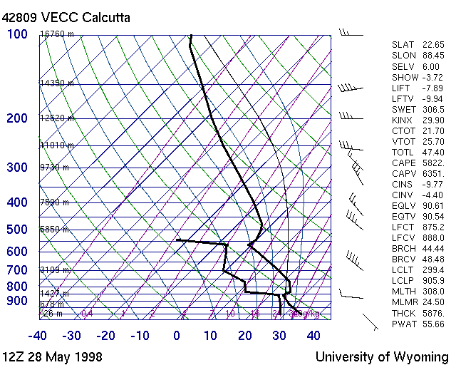
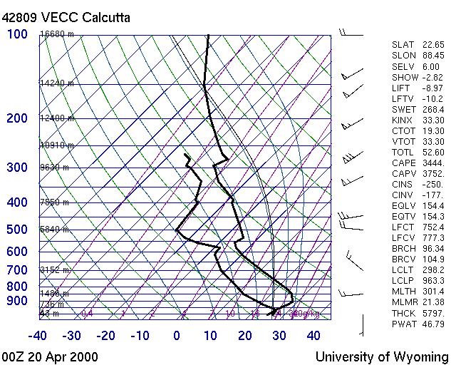
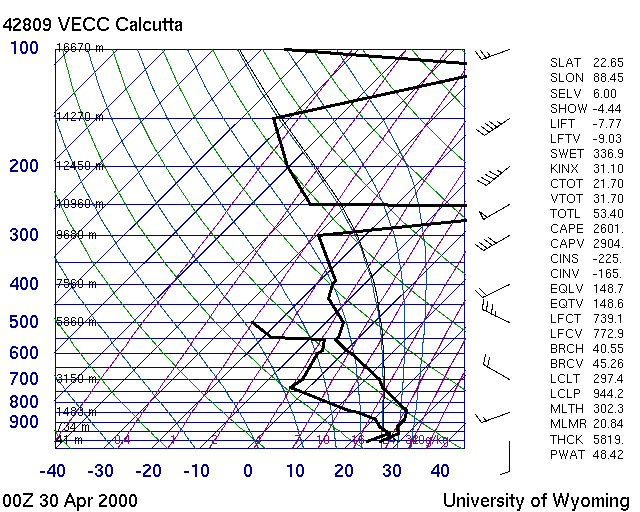
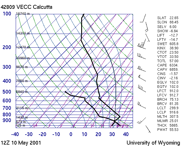
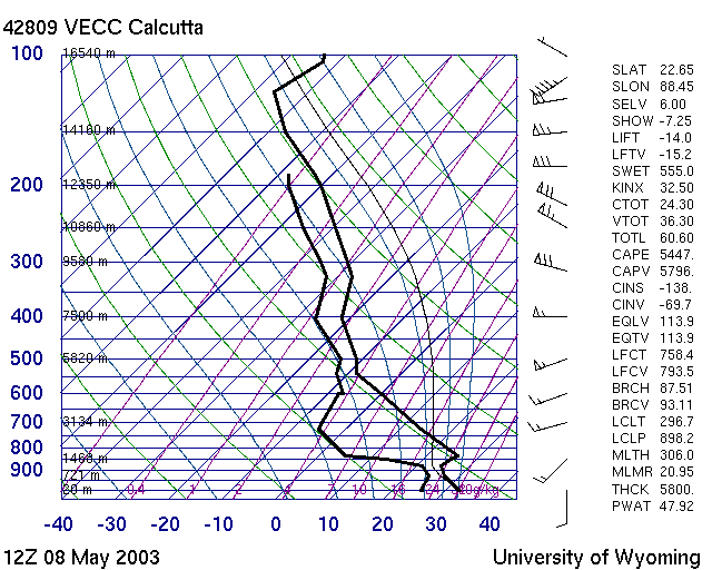
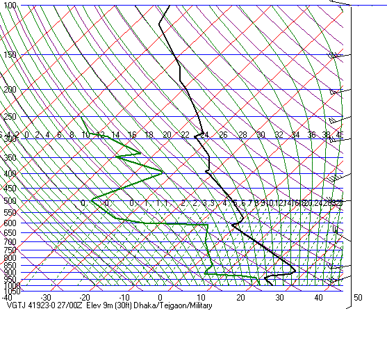
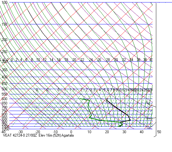
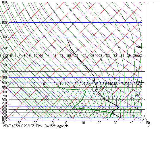
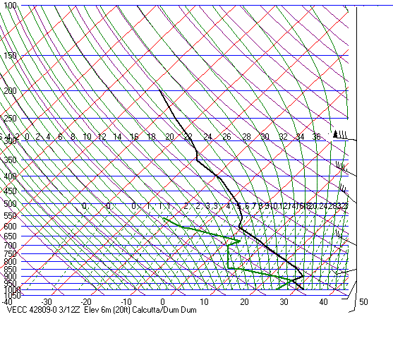
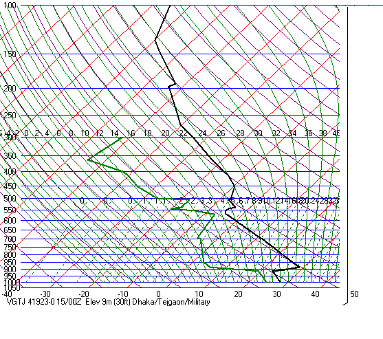
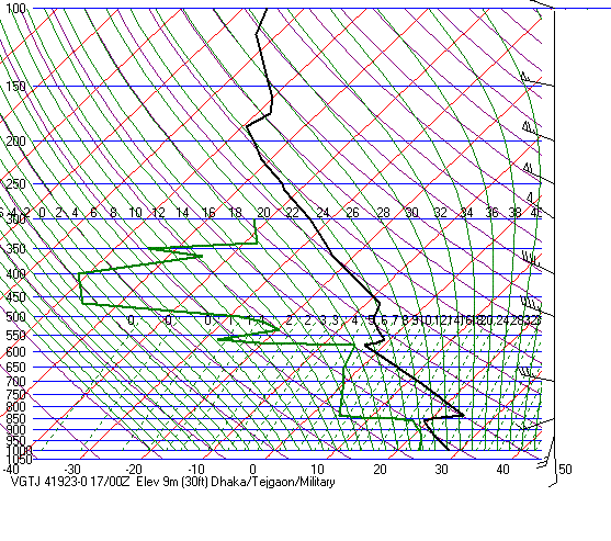
The EML is present over East
India and Bangladesh from late-March through May. The soundings below were
taken at Calcutta,
IN unless otherwise noted.
As stated above, the source
region is interior north India--not the Himalayas. Any elevated
airmass
coming off the Himalayas
would be detrimental to thunderstorm development. Instead of providing
a low-level capping inversion,
the Himalayan EML would
provide a strong inversion around 500mb with 500mb temps from 0 to +5C.
Apr
02, 1972 12Z
May
21, 1972 00Z
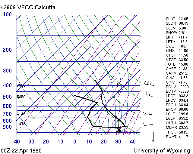
Apr
22, 1990 00Z
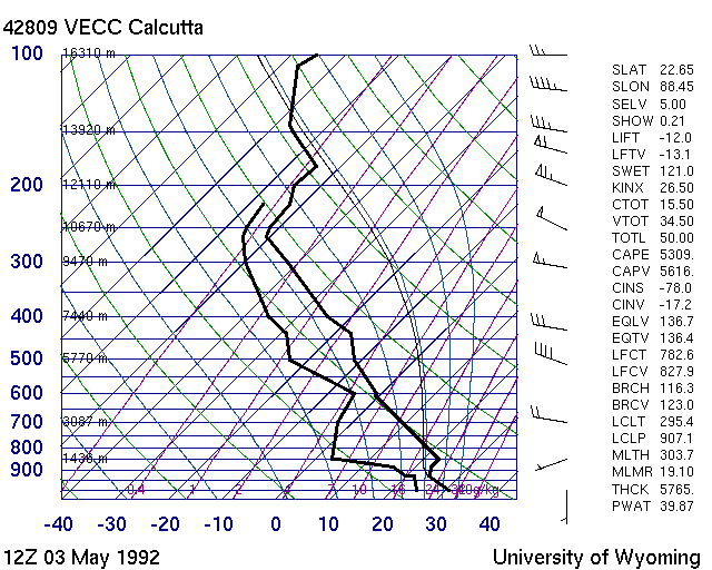
May
03, 1992 12Z
May
06, 1993 12Z
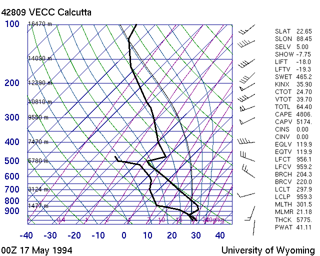
May
17, 1994 00Z
Apr
07, 1998 00Z
Apr
21, 1998 00Z
Apr
21, 1998 12Z
May
28, 1998 12Z
Apr
20, 2000 00Z
Apr
20, 2001 12Z
Apr
29, 2000 12Z
Apr
30, 2000 00Z
May
10, 2001 12Z
May
08, 2003 12Z
Mar
27, 2004 00Z Dhaka, BD
Mar
27, 2004 00Z Agartala, IN
Mar
27, 2004 12Z Agartala, IN
Mar
29, 2004 12Z Agartala, IN
Apr
03, 2004 12Z
Apr
10, 2004 12Z
Apr
14, 2004 00Z Dhaka--75 people were killed
by a tornado in north central Bangladesh from 1230-1400Z
Apr
15, 2004 00Z Dhaka
Apr
16, 2004 00Z Dhaka
Apr
17, 2004 00Z Dhaka
The EML is present across
the eastern part of southern Africa, especially in the warm season. Much
of southern Africa is high in
elevation, with a vast area
above 4000ft. Within this elevated area, there is a large area centered
around 30S, 28E which is very
high(6-10,000ft). There
is a large desert area in the western part of the country including much
of Namibia, Botswana and the
northern part of Northern
Cape. Durban, South Africa, located near 29.5S, 31E, is just east of the
very high terrain and EMLs
are a common occurrence.
Elevation really increases just inland from Durban. The marine layer really
keeps Durban fairly stable
when the EML
is in place. Oftentimes Durban will be very moist at low-levels but quite
cool. But just inland, elevated heating on
the higher terrain is often
enough to erode the cap. The area southwest of Durban(just east of the
Drakensburg mountains) has a
high incidence of
tornadoes. Storms in this area develop as moist upslope flow, elevated
heating and local terrain effects help to
break the cap. The last
major tornado to hit this area occurred on January 18, 1999, killing 21
people.
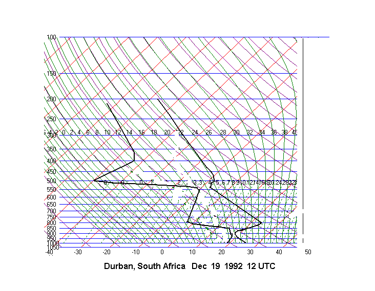
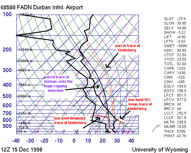
On December 15, 1998, a tornado
hit Umtata in South Africa, killing 15 people. This event made world news
since Nelson Mandela
nearly became a victim.
The 12Z(early afternoon) sounding
from Durban(near the time of the tornado) showed an EML(although
not exactly dry adiabatic)
with a strong capping inversion. The T/Td at Durban were about 27C/24C.
Inland at Underberg, only
about 90 miles from Durban,
the T/TD were 27C/16C. Despite identical surface temperatures, the surface
potential temperature
was 315K(42C) at Underberg
and 299K(26C) at Durban. This is because Underberg is 5290ft ASL while
Durban is near sea
level. Despite the much
higher surface dewpoint at Durban(24C versus 16C at Underberg), the theta-e
was actually higher at
Underberg(358K vs 355K).
Please note that a 16C(61F) dewpoint at Underberg
has the same amount of moisture as a 66F
dewpoint
at Durban. These facts explain why the cap is virtually non-existent
at Underberg and very strong at Durban. This example
also highlights the importance
of elevated heating to instability and convective initiation, demonstrates
how point soundings should
not be used to the exclusion
of other data, and shows the importance of potential temperature
instead of temperature. In addition,
as hinted at in red above,
dewpoint temperature is not an absolute measure of moisture. A dewpoint
at one elevation cannot be
compared with a dewpoint
at another elevation. Mixing ratio, on the other hand, is an absolute measure
of moisture. For more on
this, see my discussion
on elevated
heating.