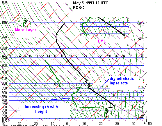
The Elevated Mixed Layer
The
elevated
mixed layer(EML) was first discussed in pioneering work by Toby
Carlson in the mid to late 1960s.
He
noted that the EML resulted in a "lid" which prevented thunderstorm activity.
His synoptic meteorology book entitled
"Mid-latitude
Weather Systems" has a chapter devoted to the "lid". This book is a must
read for meteorology students.
Most
meteorology books are highly theoretical and are frankly no fun to read.
Carlson's book actually reads like a book
and
is interesting throughout. I was fortunate enough to enjoy Carlson's advanced
synoptic meteorology course while
attending
Penn State University in 1991. While many of the courses I took in graduate
school were just about deriving
equations,
this course was very applied and I learned a lot. Yes, we learned the components
of the important equations
and
applied the equations to practical problems, but the whole course
was not based on proving ones mathematical
prowess.
The EML is important for the following reasons:
1.
The EML prevents deep, moist convection until high instability is achieved.
In the absence of deep, moist
convection, warm and moisture laden air can flow poleward in an unimpeded
manner. Daily evapo-transpiration
also adds moisture to the boundary layer further enhancing theta-e.
2.
The EML tends to keep storms isolated. When deep moist convection
occurs in a capped environment, it tends to
be in localized areas of enhanced convergence such as along out flow boundaries,
dryline and terrain features, or of
course along frontal boundaries. Isolated storms tend to be more severe
than widespread storms since there is less
competition for available warmth and moisture.
3.
The EML along the southern edge of the westerlies prevents deep vertical
mixing. Deep vertical mixing is
a CAPE destroyer. It is very difficult to maintain high mixing ratios when
very deep mixing is occurring. The cap
provided by the EML confines the moisture to a shallow layer, preventing
the mix-out effect. This effect is most
apparent in late-spring and summer when the southern edge of the westerlies
retreats to 40-45N. The high dewpoints
will usually be along the southern edge of the westerlies where the lid
is the strongest and where cold fronts
stall out. Moisture convergence is also greatest along the southern edge
of westerlies, typically just poleward of
stalled out fronts or outflow boundaries where evapo-transpiration is at
a maximum from vegetation and previous
rains. The mixout effect can also occur beneath the strong capping inversion
in early-spring when moisture return
is extremely shallow, particularly when strong synoptic-scale disturbances
are involved.
EML's develop when arid regions
heat up and deep, dry adiabatic lapse rates extend from the surface to
between 450mb
and 600mb.
Elevated mixed layers can occur any time of the year. Of course an EML
can occur along with a very stable
boundary
layer too. But this page is devoted to EML's that result in capping inversions
above a warm and moist boundary
layer.
I have found EML soundings in all seasons and all areas east of the
Rockies. The
Some EML sources include:
1.
Dry, elevated terrain of the interior, western United States
2.
High plains of the United States
3.
Sierra Madre Occidental of Old Mexico
3.
Western desert areas of southern Africa
4.
Desert areas of northern India
5.
Parts of Spain, France and Saharan north Africa
In
the cool season, the elevated mixed layer (with positive instability) can
occur over the southern United States.
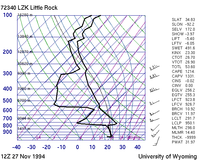
Nothern
old Mexico and the southern Rockies are the source region this time of
year. A tornado outbreak occurred
across
Arkansas and western Tennessee on November of 1994. An elevated mixed layer
off of old Mexico capped
the
moist, low-level air over Little
Rock at 12Z.
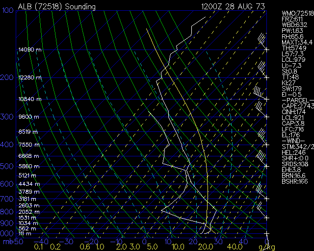
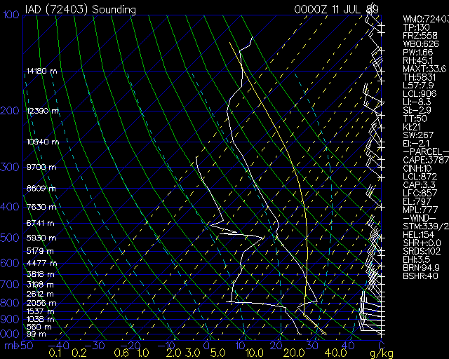
The Rockies' EML can be found
from time to time along the east Coast. Here are a few notable examples
from
prominent tornado cases:
Albany(
August 28, 1973) F4 killer tornado in Columbia county,
NY and Berkshire county, MA
Washington
Dulles(July 10, 1989) Tornadoes family moved SSE from eastern NY
to New Haven, CT to Long Island
to Putnam county, NY
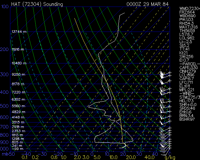
Hatteras
(March 28, 1984) At least 2 tornadic supercells, one
of which produces many tornadoes over a 5 hour period,
killing 57 people
Of
course elevated mixed layer soundings are commonplace in spring and summer:
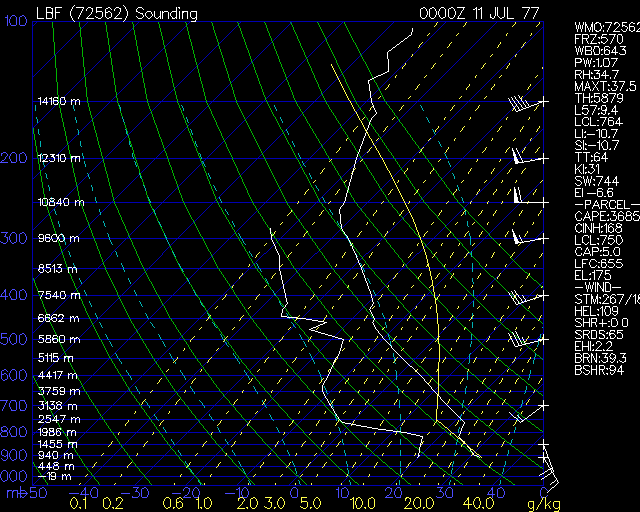
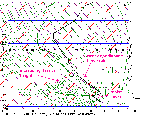
North
Platte (July 10, 1977) F3 tornado in Cherry county, NE and
Bennett county, SD
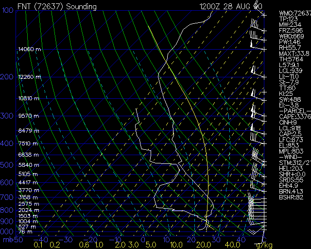
Flint
(August 28, 1990) Plainfield F5 tornado
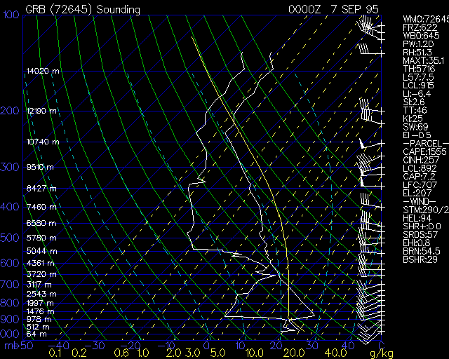
Green
Bay (September 6, 1995) F2 tornado Rice county, MN
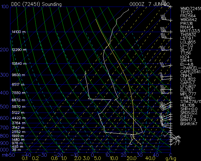
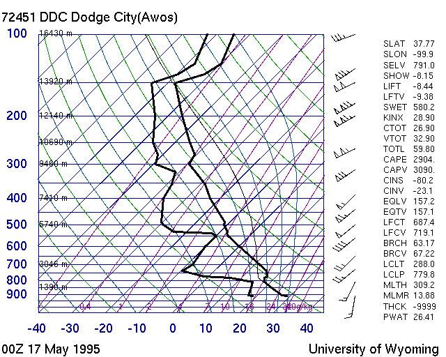
Dodge
City (June 6, 1990) Limon, CO tornadoes
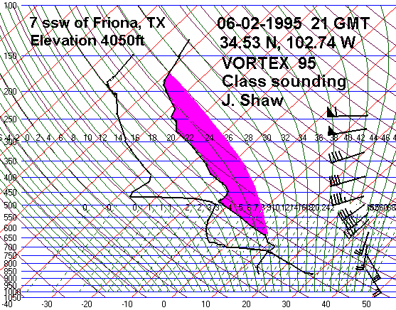
Friona,
TX (June 2, 1995) Large tornadoes near Dimmit and Friona,
TX
Amarillo,
TX (March 19, 1982) Long-track F4 tornado TX, OK panhandles
North Platte (May 17, 2000)
Large tornado at Brady, NE
Dodge
City (May 16, 1995) Tornadoes in western Kansas
The EML is present over East India and Bangladesh from late-March until
early-May. I will post some of these soon.