Back to Lubbock Area Tornadoes Webpage
Back to Amarillo Area Tornadoes WebpageOverview
The Opdyke-Whitharral-Littlefield tornado
A tornado developed southwest of Smyer around 535-540 pm. Witnesses describe multiple funnel clouds. A tornado
was observed
by many onlookers at the Spade ranch in Smyer for 20 minutes. The owner
of the ranch, Joe
Christopher,
assured everyone that it was too cool for a tornado. This tornado(es)
moved northwest and northwest.
Mr. Avery said
that one big tornado moving from the southeast merged with a smaller
tornado and formed a giant tornado
south of
Whitharral. The two photos shown here were taken by Avalanche
staffer John Rogers who had to be pulled
out of the
flood waters. Baseball to softball sized hail fell with the storm
before the tornado struck according to Avery.
The tornado
hit near
Whitharral between 6 pm and 630 pm. After hitting
{1 mile south and 1/2 mile west) and (2 miles
north and
1.5) west
of Whitharral, the tornado turned to the north-northwest and passed 5 miles southwest of Littlefield
and 4 miles
west of Littlefield. Deputy Sherriff Elson Mcleese had his car tossed around on highway 84 due south of
Amherst.
The time of
this event in the papers was 930
pm. In order for this to be the same tornado that hit Littlefield, the
time must
have
been much earlier. The tornado knocked down
18 power poles in this area. Tornadic damage also occurred 1/2 mile
east of Amherst. This tornadic
storm missed all towns but caused major rural damage.
Two
houses were destroyed on the L.W. Hill farm east of
Levelland(1 mile east and 1.5 miles north of the Opdyke gin). The Hill's
and Mexican
laborers were not home. Numerous sheds and barns were
destroyed and irrigation
pipes disappeared. The
Reuben Mayes
home was destroyed as well as
the tractor and pickup. The family was not
home. The home owned by Joe
Dominguez near
Opdyke
was destroyed. Homes owned by Joe Pelfrey, Sylvester(Clyde)
Brock,
and Will Redding were
destroyed west
of Whitharral.
The Charley Vineyard rent
home was destroyed. F. E.
Sadler saw the funnel approaching and
escaped in a
pickup.
Almost everything
around his residence was heavily damaged.
Several motorists between Whitharall and
Littlefield
sought shelter in
the Water's storm shelter. The Water's had guests at
their house for easter and they all took shelter.
5 cars and a
pickup were tossed
like toys and hurled into fields. The Walters had 26 people in their
storm cellar. A car
was
hurled 1/2 mile close to
the Water's shelter(2 nw
Whitharral), with a
board driven though the frame and into the front seat.
Hens from the
Walter's brooder house were lying dead all over the place. The cars and
trucks that were parked outside the
house were
scattered over a 1/2 mile and demolished beyond repair.
Every imaginable automobile part could be found
strewn
in the fields.
The hood of one are was several hundred feet from
the car itself. Household items were
scattered for a half mile.
A tractor
parked on the south side of the
house which lowered the plows in the rear
and the tractor was blown through the
house, plowing
furrows right
through the foundation and on past the house on
the other side. Only the foundation of the house
was left.
Waters
indicated that 2 tornadoes hit his farm--one from
the east and the other from the south. The first tornado
destroyed the
brooder house then the second tornado hit. Several
persons on the Avery farm 1 mile south of Whitharall went
into
a
storm shelter. Only some boards remained where the Avery farm
house was, with only a couple of tractors recognizable. A
storm shelter
saved 14 people in the Herrin house as
the house was destroyed. A brand new pickup and combine
near the
Herrin house
were hurled over 300
yards. Eleven homes were destroyed between Whitharral and Opdyke.
Several people
took refuge
in the
Lumsden-Perkins gin 4 miles west of Littlefield. The Lopez family took
shelter behind the gin in their car.
They were buried in
rubble as the gin was destroyed. Several shacks owned by Latin american
workers were destroyed.
Wanda Fry and
her sister were driving between Levelland and Littlefield and their car
was flipped over several times. Other
homes
destroyed near Whitharral belonged to John Waters, Ben Waters, Robert
Avery, and Myrtle Douglas. Texas highway
patrolman Bud
Simmons described the funnel as the
"largest funnel I've ever seen, and I've seen lots of them." He
said
the
funnel was at
least 1/4 mile wide and possibly wider. According to
Simmons who tracked the tornadoes,
hail the size of eggs
fell with the
tornado near Whitharral. Simmons
alongside Ted Court found that little was
left of most of the houses, with furniture,
refrigerators
and butane
tanks scattered across the fields. Their "tornado hunt"
was ended by 3 to 4 foot flood waters that
stalled their
vehicle.
Five homes were destroyed in the Whitharall
rural area. B. F. Waters came out of a storm shelter to find his
home
demolished. Thirty people were injured
southwest and west of Littlefield. Mrs. Jim Shipman, Mrs.
Claudio Lopez
and Mary
Brooks(4 sw Littlefield) suffered
pelvis, shoulder or back injuries. After passing 4
miles west of Littlefield, the tornado
continued
north to north-northwest and passed 1/2 mile to 1 mile east of
Amherst. Barns
and outbuildings were damaged or
destroyed on properties
owned by Ben Greener(2 ne Amherst), Barney Sherrill, Forest Nutall,
Pete Thompson,
Leon Sherrill,
Larkin
Nix and Maud
Bennett. The Charley Vineyard house located 4 miles northwest of Opdyke(half
way between Opdyke and
Whitharral was
damaged and the hired hand house was destroyed. The
Bud Mayes(Reuben Mayes) home 1/2 mile south and 1/2
mile east of
the Vineyard
home was destroyed.
Hart Camp tornado
A tornado
developed north of Lubbock around 845 pm and moved northwest to Hart
Camp and then to southwest of
Olton by
10 pm. This
tornado caused extensive rural damage but missed
all towns. This tornado may have been
produced by the same storm
that spawned
the tornado southeast of
Lubbock. This tornado caused extensive
damage in the Hart Camp area. Pat Pickrell of the
Littlefield
Press office staff talked about the tornado as it moved
across rural areas between Spade and Abernathy. She said that
she
was driving fast to get home before the roads
became muddy when she encountered the tornado 7 miles east of Spade.
Power
lines were
torn down and telephone
poles were left as stumps. A barn owned by Joe Blankenship was was
damaged only 200 yards
from her
house. No homes were hit but several barns were destroyed. The
Prentiss home was completely swept away 2 miles
southeast
of Hart Camp
at 915 pm with parts of the house
wrapped around the neighboring Neinast home. Nothing was
left of the house
including the
furniture. The J. W. Wells home was
destroyed but the southwest walls were left standing and
some of the furniture was still
undamaged. The
Mcafee
home was heavily damaged with outbuildings
completely disappearing. The H. R. Monroe home north
of Spade was
heavily damaged. Farm buildings were damaged on the A. Farr farm.
The Neinast home was heavily damaged.
Damage
in the Hart
Camp/North Spade areas was $1/2 million. This
tornado apparently continued to the northwest
since outbuildings were
destroyed 6
miles southwest of Olton with farm
homes unroofed. The tornado apparently hit
southeast of Hart Camp at 915 pm
and Hart
Camp around 930 pm. The Lilly McGill home was damaged 5
miles sw of Olton(3 s and 4 w). The Paul Burrus farm was
damaged 5.5
miles sw of Olton. Barns and outbuildings were destroyed 6 miles sw of Olton. Wayne Monroe, 9
years old when the
tornado
occurred, told me that a barn was anhialated
down to the foundation on their farm.
The Shallowater-Anton-Spade tornado
A tornado developed south of Shallowater and moved northwest to 2 miles east of Anton and to 4 miles east of Littlefield
and then
to 4 miles
east of Amherst. The time of this tornado is in
question. One estimate was 730 pm as clocks
stopped south of Spade.
Another time
was 845 pm and this was probably
more accurate. The storm that caused
this tornado is probably the same storm that
produced the
tornadoes
south and southwest of Lubbock. This tornado
missed all towns but caused extensive damage to rural
homes. The
David
Mcvey home was damaged 2
miles east of Anton. The family took shelter at 8 pm and the home was
hit at 845 pm.
Walls were
left standing
but the roof was gone. The garage was destroyed. The George Sooter home
was unroofed 3 miles
southeast of
Shallowater. The garage was demolished. The family was in the storm cellar. On
the J. E. Paden farm 3 miles west and
3 miles south
of Spade, all the walls were flattened and barns were leveled. The pump
house was unroofed. The Leonard King
home
4 miles east
of Littlefield(2 south and 4 west of Spade) was
unroofed. The A. W. Duncan home 2 miles
northwest of Shallowater was
destroyed. The
pickup was rolled on top of the rubble. The entire family was in
the storm cellar. The George Sooter home southwest
of Shallowater
was unroofed. The last damage from this
tornado was to Clyde Brock's house 4 miles north of Littlefield. A
pickup
belonging to
Leonard king was thrown 400
yards into a pasture and parts of the pickup were thrown for 1/2 mile. The Kings made a
dash
for the cellar
when they saw and only made it to the sw corner of the house
when the
tornado hit. All that was left of the house was
the little
room where they were huddling. A funnel cloud
was observed from Resse AFB at 804 pm to the northeast(5 miles). This
funnel
was probably
produced by the same storm that hit
the southern outskirts of Lubbock around 730 pm. At 730 pm a tornado
was sighted
from the
Lubbock airport 10 miles south of the
airport. At 743 pm and 745 pm, Reese AFB and the Lubbock airport
observed a funnel
cloud 10 miles
southeast and 10 miles southwest
respectively. They were likely looking at the same funnel(not a
tornado). This is
in
agreement with the fact
that no damage occurred in the
Lubbock clty limits.
The Mayfield Tornado
Another
tornado hit near Mayfield and then moved to the southeast of Olton and
continued to 5 miles north of Olton. Homes were
unroofed near
Mayfield and a wood frame shop owned by Fred Long was
totally destroyed 5 miles north of Olton or just north
of the
Running Water
Creek.
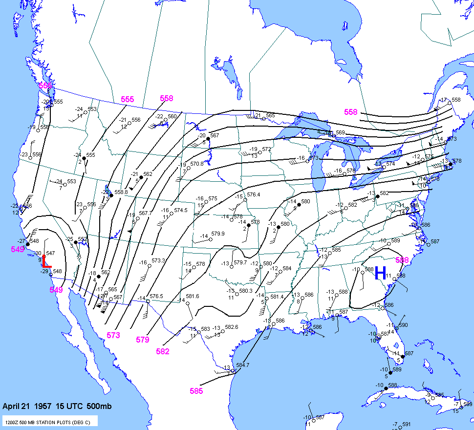
15 UTC April 21 700mb
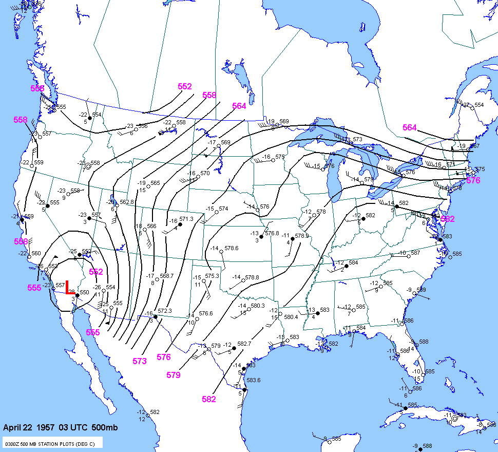
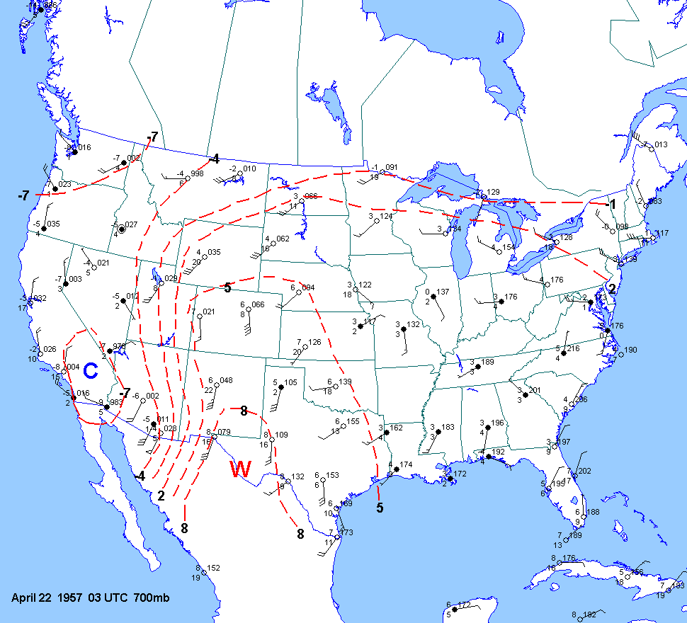
03 UTC April 22 700mb
850mb charts
03 UTC April 22 850mb250mb charts
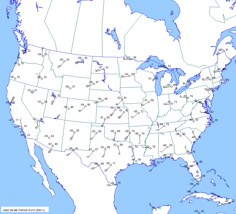
15 UTC April 21 250mb
03 UTC April 22 250mb
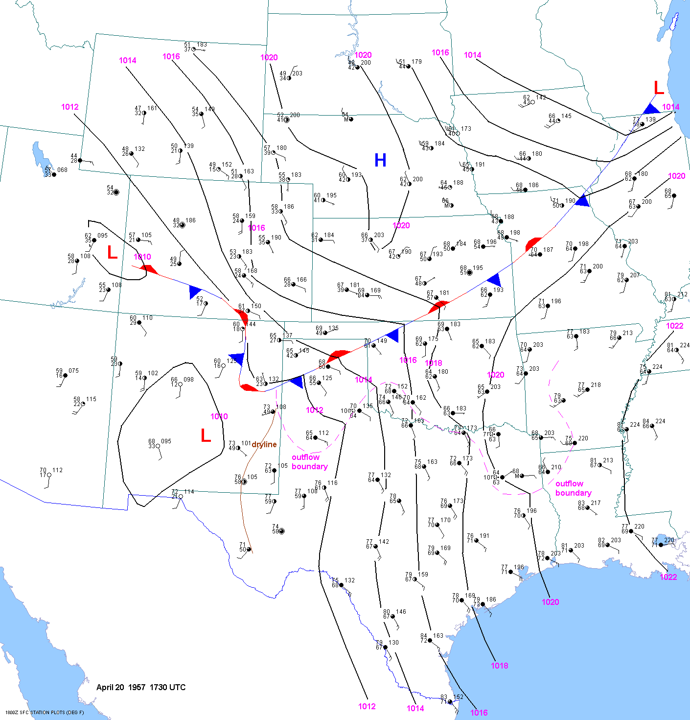
1730 UTC April 20
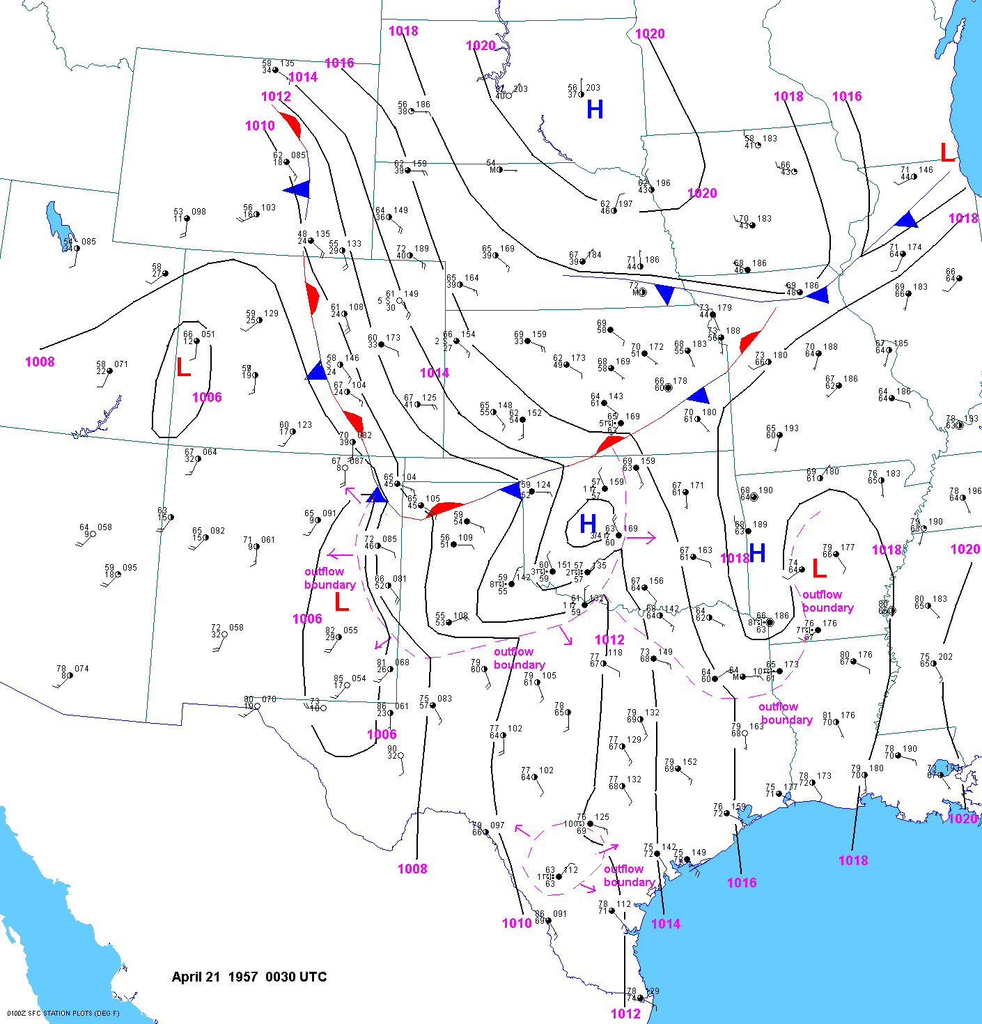
0030 UTC April 21
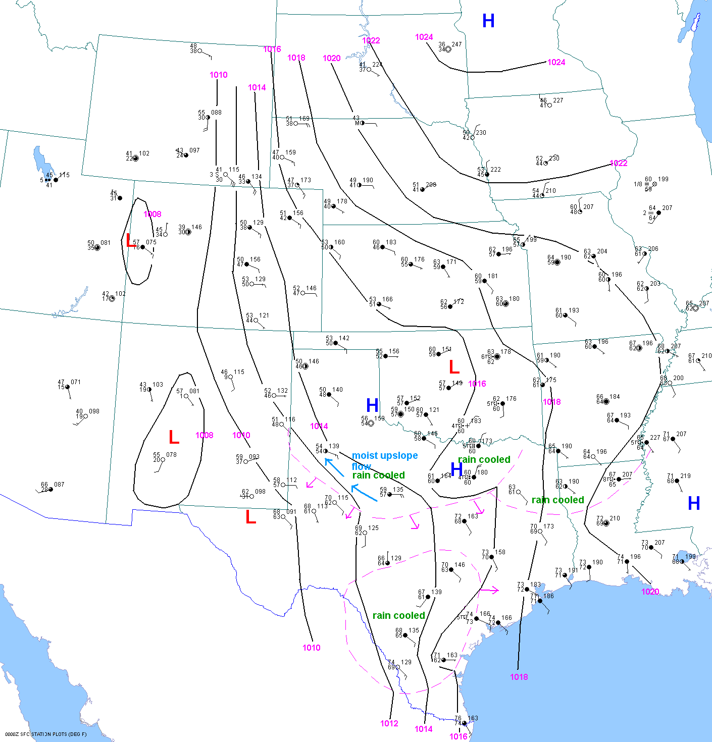
When one
thinks of upslope flow on the high plains, west Texas is usually not the
first place that comes to mind. I tend to the
McCook-Sidney-Cheyenne-Scottsbluff corridor southward into northeast
Colorado. But upon inspection of a topographic map,
one
can readily see that southeast
to east to northeast low level flow in the Lubbock area
is definitely
upslope. In fact, upslope
flow in west
Texas can have a dramatic
impact
on weather conditions. Air that flows westward from
Hall, Cottle, King, Stonewall
and
Childress counties onto the "Caprock"
has to ascend about 1200-1500ft in 25 to 50
miles. The elevation gradient is not
as great in
the Texas panhandle to the north and Edwards
Plateau to the south. This can lead
to higher surface pressures, cooler
temperatures
and
higher dewpoint
temperatures in west Texas. Despite
the
"coolness" of the air, when the sun breaks out along
the southern
edge
of such an airmass it can become very unstable.With
lowering surface pressures to the southwest due to
downslope flow
and
intense daytime heating in the clear air, the
ageostrophic low level flow can become very strong.
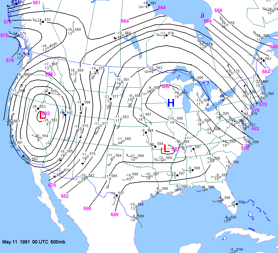
A similar setup(at upper levels) occurred on May 10, 1991. A strong tornado moved northwest near Pep, TX.
Approximate sounding for Lubbock for 00z April 22 1957