The Cheyenne Ridge Tornado
April 23 1960
Jonathan D. Finch
rough draft form
Historical Tornado Cases for the Boulder Warning Area
Historical Tornado Cases for the Cheyenne Warning Area
Historical Tornado Cases for the United States
May 7-8 1965 Front Range Tornado
June 14-17 1965 Front Range Superstorm
Elevated Mixed Layer
Elevated Heating
High plains and front range topo maps
Brief Overview
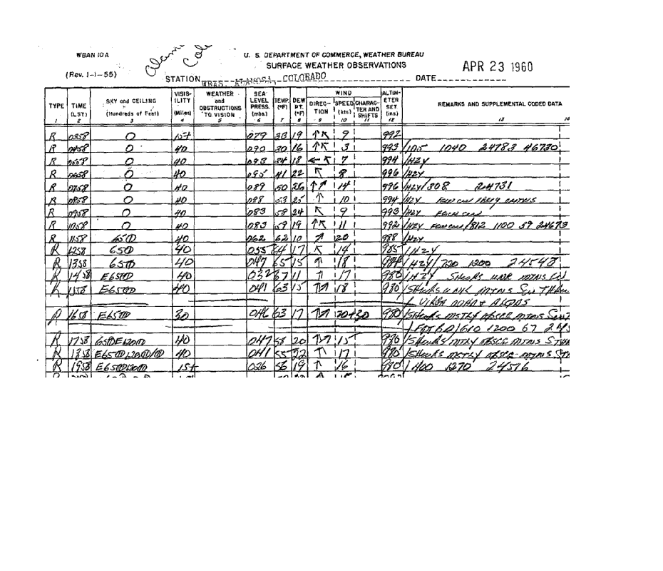
On April 23, 1960 , a thunderstorm developed near Fort Collins, Colorado. This storm moved north-northwest and
and became severe, producing tornado(es) in western Laramie county in Wyoming. The tornado touched down
southwest of Granite, Wyoming and moved northwest or north-northwest into eastern Albany county (elevation
7600-7900ft). The tornado was observed for about 25
to 30 miles. The tornado(es) was in very rural areas for most
of its life cycle, doing most of the damage near
Interstate 80. The tornado did no documented damage as it moved
into the Medicine Bow National Forest (elev.
7700-8200ft) in eastern Albany county. Due to the lack of
documentation, I didn't draw the tornado path this
far north and west.
Synoptic setup leading up to the Tornado
The 00z April 23 1960 500mb chart showed 2 branches of the westerlies, one from Old Mexico into the southern
plains, and another from southern California into
western Utah. Moisture was streaming north from the Gulf of
Mexico with dewpoints in the 50sF as far north as
Nebraska. Moisture was present north of the surface
front across the nothern plains with 750mb dewpoints/mixing ratios around > 5C / 7.5 g/kg). I used surface
observations to augment the upper air observations.
For example, mid afternoon, mean T/TD values of 73F/47F and
and 75/41 were recorded at Alliance, NE
(elev. 4000ft) and Scottsbluff, NE (elev. 4000ft) respectively. The
moist layer probably extended up to 750 or even
700mb. In the case of Alliance, the mixing height would be
5000 ft, assuming the dewpoint was correct. This
would mean that the top of the moist layer at Alliance would be
around 9000ft (~725 mb) with a 750mb dewpoint of
about 43F(mixing ratio 8 g/kg). The surface observation sheet
for Alliance indicated building cumulus clouds in the remarks. The top of the moist later at Scottsbluff would be
675mb, with a 750mb dewpoint of 37F(mixing
ratio 6.2 g/kg).
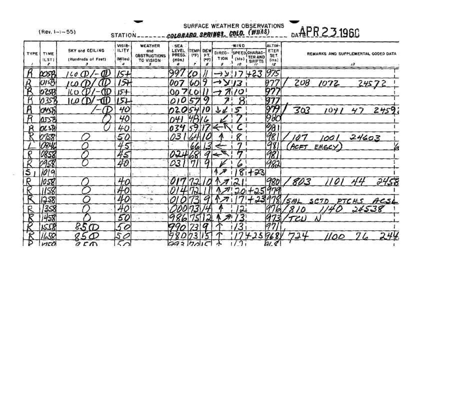
At 00 UTC April 23, a weak cold front was about to push through Cheyenne where the dewpoint jumped into
the upper 30s by 01 UTC, along with a wind shift to
the northeast. The airmass north of this boundary in the Nebraska
panhandle was actuallly moderately unstable
in the
afternoon, but was becoming less unstable by 00 UTC.
Dewpoints were in the 40sF in the Nebraska
panhandle. A
sharper frontal zone was located from southern Montana
into northern SD. The surface dryline was
rather ill-defined in
Colorado but was more pronounced in west Texas,
buldging east of Amarillo. A cold surge
was apparent west of the Big
Horns. A pacific cold front was located over
western Utah.
By 03 UTC April 23, convective outflow was apparent in western Kansas, eastern Colorado and southwest
Nebraska.
By 06 UTC, the weak cold front had apparently pushed through Denver as the sea level pressure jumped and
the dewpoint jumped into the upper 30sF. The
northern cold front was progressing south into southwest SD.
The northern front moved through Chadron after 3 UTC (22 MST). Note the abrupt wind increase, pressure rise
and drop in dewpoint.
By 09 UTC, the northern cold front was approaching Scottsbluff. Drier air had filtered into Chadron and Rapid
City. This front was overtaking the southern front.
Drier air had filtered into Scottsbluff by 09 UTC. Notice the
drier air, pressure rises and dewpoint drop
between 02 MST and 06 MST. The dry air intrustion may have been
fairly shallow. The area of outflow over northwest Kansas and southwest Nebraska eroded
from the south overnight
with southerly low level winds shoving the rain
cooled air further north.
The northern cold front passing Cheyenne around
12 UTC was accompanied by low clouds, fog and strong
pressure rises between 0500 and 0600 MST.
By 12 UTC April 23, two branches of the westerlies
were still evident. A deep 500mb trough was still parked in
the western US. The flow over the Rockies was
meridional with the eastern edge of the strong flow from central AZ
into western Colorado and central Wyoming.
Ample elevated moisture was still in place north of the surface front,
with
700mb/750mb dewpoints from 3 to 7 C (6 to 8.5 g/kg).
The 15 UTC surface chart showed north winds in eastern Wyoming and western Nebraska. But surface dewpoints
in the cool air were still 40F at
Cheyenne(mixing ratio 6.5 g/kg) and 42F (mixing ratio 6.5 g/kg) at Sidney,
NE.
Dewpoints were in the mid 40s to lower 50sF
immediately north of the surface front in northeast Colorado and
southwest Nebraska. For example, Imperial, NE and
Akron, CO had dewpoints of 53F and 46F
respectively
(mixing ratios 9.2 g/kg and 8.3 g/kg. Thus, given
that the mixing ratios at the surface and 750mb were between
7.5
and 9 g/kg east of Cheyenne in the morning,
strong upslope flow would tend to advect this higher
theta-e air onto the
front range later in the day. The surface
pressure at Cheyenne was about 800mb, so the lowest 50mb of
moisture
should have an average mixing ratio of 8
g/kg later in the day.
By 18 UTC, the surface winds were beginning to turn upslope in western Nebraska, northeast Colorado and southeast
Wyoming. By 21 UTC the dewpoint at Cheyenne had dropped to 38F due to vertical mixing. However, dewpoints
just southeast and east of Cheyenne still ranged
from 49 to 53F. I do not know if the surface observation at Fraser,
Colorado is reliable, but Fraser seems to be north
of the front at 23 UTC. I am suspicious of the dewpoint temperature.
Here is the 22 UTC surface chart.
At 23 UTC, there was a narrow corridor of higher dewpoints from southwest Nebraska and the southern Nebraska
panhandle into northeast Colorado. The dewpoints at
Sterling, CO, Imperial, NE and Sidney, NE were 54F,
51F and 49F respectively. The surface pacific cold
front was still west of Vernal, UT and Rock Springs, WY and
just west of Grand Junction, CO. I chose to draw the dryline
just east of Grand Island, NE since the moisture
was mixing out immediately ahead of the front.
This is not the
only solution. The surface cold front in Nebraska was
now surging south. In fact the western end of the
frontal push
was around North Platte. Another baroclinic zone
appeared to be entering the northern Nebraska
panhandle.
Lifted Index Technique Without Upper Air Data
I roughly estimated the 500mb temperatures
across much of Wyoming and Colorado at local noon based on
a technique that I have been using for several
years. This technique was partially based on Dr. Toby Carlson's
pioneering work with the elevated mixed layer(EML)
in the mid and late 1960s. Carlson was to first to document
the existence of the EML. He used local noon
surface temperatures over the dry and well mixed western US to
calculate the dry adiabat that the well mixed
temperature fell on. Hence, if you know the local noon surface
temperature, you can estimate the potential
temperature and 700mb temperature since the low to mid levels are
dry adiabatic. In fact, I found that I was able to
estimate the 500mb temperatures in very deep mixing situations.
The surface dewpoint depression should be at least
50F and preferably 60F and the station must be in the warm
sector
in windy conditions, with a station elevation > 6000ft. Stations such
as Casper(5300ft), Rawlins(6813ft),
Laramie(7270ft), Rock Springs(6760ft),
Gunnison(7700ft) and Alamosa(7600ft) typically mix out to 500mb by
noon in windy, warm sector situations. Stations
such as Denver(5300ft), Colorado Springs, Albuquerque
and
Las Vegas occasionally mix to 500mb, but it
generally takes until later in the day. I used the noon local
temperature
for the stations that usually mix out quicker. In
these cases, the high temperature is typically 1 to 4 degrees higher
than the noon temperature, leading to slighly
superadiabatic low levels in the late afternoon. But in windy conditions
the super is usually much less pronounced since heat
cannot build near the ground. In the absence of strong cold
advection, these 500mb temperature estimations
are still valid for that evening. In the later case(sites that mix
out later in the afternoon) I use a variation
of this technique. I subtracted about 3 degrees from the maximum hourly
temperature in the afteroonoon and considered this
to be the mixout temperature. If a station experienced a warm
frontal passage in the afternoon, I use the mixed
out temperature following the frontal passage. Of course, once
you know the 500mb temperatures in the region of
interest, and the 500mb flow pattern, you can estimate the
500mb temperatures for locations immediately
downstream. In well mixed situations discussed here, the wind is
typically unidirectional from the surface to 500mb.
Lifted Index Calculation Without Upper Air Data
1. Using noon surface observations
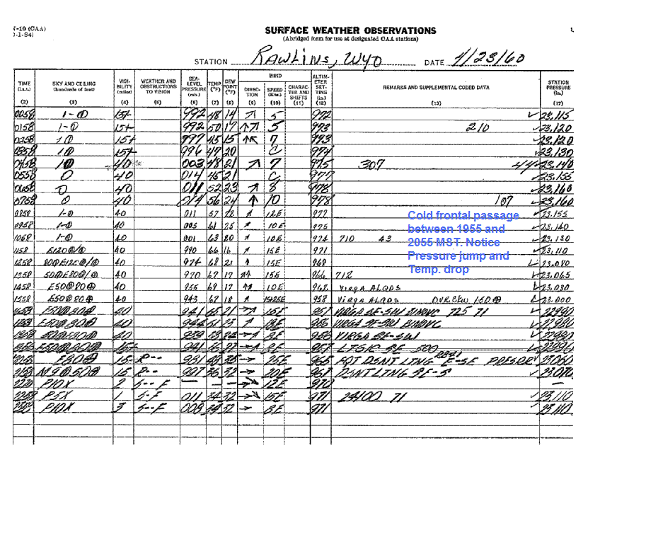
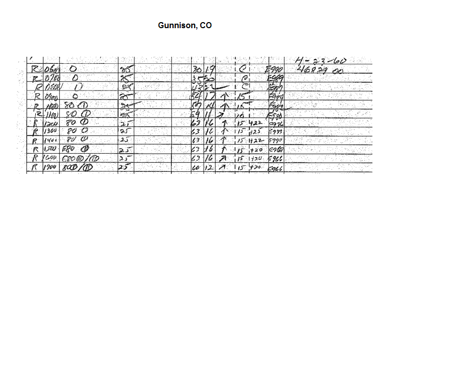
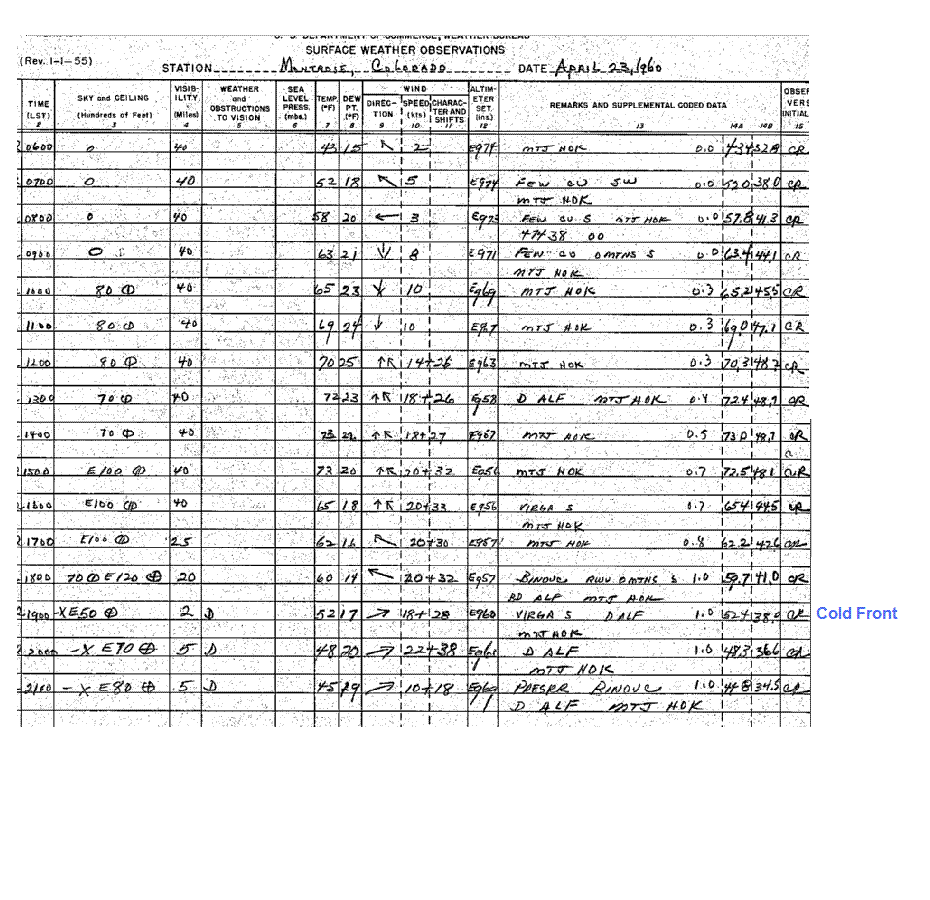
The 19 UTC surface observations at Rawlins,
Gunnison, Rifle, Montrose and Colorado Springs were used
in estimating lifted index in the tornado
affected area at 02 UTC. The following table shows the elevation,
station
pressure, T/Td, mixing ratio, surface potential
temperature. The 500mb temperature was calculated from these
and are shown in the last column. Alamosa
may not have completely mixed out by 19 UTC since max
temperature
was 67. So the 500mb temperature
approximation may have been too cold there.
Surface winds in the warm sector (well west of the
tornado affected area) were
mainly from the south-southwest
and afternoon temperatures did not fall. If 500mb
temperatures had been
falling, then sfc temps would also be
falling since the vertical temperature profiles were
dry adiabatic. There was
definitely no cold front aloft as far east
as Cheyenne or the tornado affected area by 01-02
UTC. In the later case(sites that mix out later in
the afternoon)
I used a variation of this technique. I
subtracted
about 3
degrees from the maximum hourly temperature in the
afternoon and
considered this to be the mixout temperature.
The station pressures in millibars were calculated
by multiplying the station pressures in inches of HG by 33.86.
The hourly station pressures are available on page B of the surface observation forms.
| 19 UTC |
Elev(ft) |
Pres.(mb) |
T(F)/Td(F) |
Max T |
theta(F) |
500mb T |
| Rawlins |
6813 |
782 |
66/16 |
69 |
104.2 |
-16 |
| Gunnison |
7678 |
760 |
63/16 |
63 |
105.5 |
-16 |
| Rifle |
5540 |
820 |
73/25 |
|
104.0 |
-16.5 |
| Montrose |
5759 |
815 |
70/25 |
|
101.8 |
-17.5 |
| Alamosa |
7539 |
765 |
62/10 |
67 |
103.4 |
-16.5 |
| Colo. Springs |
6140 |
803 |
72/11 |
75 |
106.4 |
-15.5 |
The
surface T/Td/P at Sterling, CO (3900ft), Sidney, NE, Akron and Cheyenne, WY at 19 UTC were
67F/51F/870mb, 65/48/860mb, 66/49/851mb
and 66F/38F/804mb. Given the estimate of 500mb temperature
of -15C at Colorado Springs at 19 UTC, an estimate
of the lifted indices at Sterling, Sidney and Akron are
-4.5, -3.5, -5 and -4.
2. Using only the 00 UTC surface observation from Denver
In the case of April 23, 1960, the surface
observations at Denver around 00 UTC were used to estimate the
01-02
UTC lifted index at Cheyenne.
In this case, Denver mixed out late in the afternoon after a warm front
moved
north of the station.
| 00 UTC |
Elev(ft) |
Pres.(mb) |
T(F)/Td(F) |
theta(F) |
500mb T |
| Denver |
5360 |
822 |
77/7 |
108.3 |
-14.5 |
The surface T/Td/P at Cheyenne at 01 UTC were
64F/46F/800mb. Obviously, there was a strong push of most
air into the Cheyenne area. The surface observations from Cheyenne indeed confirm this. Note the windshift to the
east-southeast, along with a moistening and slight
cooling between 22Z and 01Z. Using a 500mb temperature of
-14.5C yields a surface based lifted index of -7.
3. Using only the 00 UTC Denver sounding
The 00 UTC Denver sounding(text format) confirmed the above finding that the 500mb temperature was around
-14.5C. Of course, using this sounding with the
01-02 surface observation from Cheyenne gives a lifted index
of -7.
Elevated Heating on April 23 1960
As experienced storm chasers
are well aware, severe thunderstorms occur on the high plains with much
lower
surface dewpoint temperatures than at low
elevations. For example, supercell thunderstorms occur in spring and
summer
with dewpoints only from 3 to 15C(37 to 59F). Exactly
why can we get by with lower dewpoints and still
get explosive storms?
The answer is twofold. In answering this question
I would like to correct a common
misunderstanding concerning dewpoint temperature.
I have often heard
something like, "wow Cheyenne
has a 60F
dewpoint, thats like a 80 dewpoint at our
elevation". This is
incorrect. The dewpoint lapse rate is only about
1F /1000ft.
This means that a 50F dewpoint at CYS has the same
moisture
as roughly a 56F dewpoint
at Houston. This
corresponds
to a mixing ratio of 9.6g/kg. In June, if the dewpoint at Houston
is 56F, then the CAPE is
probably
close to zero for
any reasonable 500mb temperature. But at Cheyenne, if the wind is from
the east or southeast
and the
dewpoint is 50F(same
amount of moisture), then interesting things can happen. Obviously
it is not the
high moisture content that
is responsible for a threat of storms at Cheyenne.
1. Sounding Comparison--Cheyenne vs Fort Worth
First, let's compare the 00 UTC Fort Worth sounding to an approximate 01 UTC sounding for Cheyenne, WY.
I used 01 UTC since the rich moisture arrived in
Cheyenne between 00 and 01 UTC. It is interesting to note
that the Cheyenne sounding starts where the
moist layer
ends at Forth Worth (800mb). The boundary layer at
Cheyenne is at the nose of the cap at Fort Worth.
The level
of free convection(LFC) is actually higher in the Fort
Worth sounding since the cap is so strong there. The
LFC is fairly
low at Cheyenne owing to high 0-5 km lapse rates.
The surface and boundary layer mixing ratios are
lower on the Cheyenne sounding than on the Fort Worth sounding.
However, the surface is potentially much warmer
at Cheyenne. When judged on a level playing field (comparing
potential temperatures), one can easily
see that the low-level thermal profile is much warmer at
Cheyenne. Now
take the surface T/TD at both locations up dry
adiabats to the LCL and then trace the parcel curves up moist
adiabats. You will see that the parcel curves are
nearly identical. This means necessarily that the theta-e is nearly
identical at the two stations.
2. Comparison of Surface Observations
I calculated the mixing ratio, potential temperature
and equivalent potential temperature(theta-e) for several stations
at 02 UTC. The closest surface observation to the
storm was Cheyenne(elev. 6140ft), located about 23 miles to the
east of the tornado path. Luckily, Cheyenne was
close to the theta-e ridge and on the inflow side of the tornadic
storm.
Since no observation
was available at higher elevations closer to the tornado, I decided to
make an approximation of
the T/TD near the location
of the tornadic storm. The tornadic storm first did
damage south of
the interstate between
Twin Mountains and Granite and then moved
to the north-northwest. The tornado moved into uninhabited
areas to the
east of Green Mountain near the Albany county
line. Along the path of the storm the elevation was mainly
7600-7800 ft.
In uplsope scenarios, it is often potentially
warmer on the higher terrain. However, since low clouds
were absent on
the lower terrain, we assumed similar surface
potential temperatures at Cheyenne and west of Granite. Since the
dewpoint
lapse rate is 1 deg F/1000ft, and since the elevation of the
tornado and Cheyenne are 7700ft and 6140 ft,
the dewpoint would have been 1.5F lower at 7700ft,
assuming the mixing ratio was conserved in the upslope. In my
experience, mixing ratio is not conserved in upslope
flow since
some mixing occurs from mid levels on the higher terrain.
I am estimating that
the dewpoint was around 42F in the inflow of the tornado affected
areas. So the T/Td were probably
about 56F/42F with mixing ratio 7.5 g/kg.
Now let's compare the mixing ration, potential
temperature and theta-e at selected locations at 02 UTC. Keep in mind
that the surface observation at Granite 3W was
approximated.
| 02 UTC |
Elev(ft) |
Pres.(mb) |
SLP(mb) |
T(F) |
Td(F) |
MR(g/kg) |
theta(F) |
theta-e(K) |
| Granite 3W |
7700 |
757 |
997.0 |
56 |
42 |
7.6 |
99.0
|
334.0 |
| Cheyenne |
6140 |
800 |
998.4 |
65 |
46 |
8.3 |
99.5 |
336.6 |
| Dallas |
487 |
994.5 |
1011.9 |
78 |
61 |
11.7 |
78.8 |
333.5 |
| Galveston |
6 |
1016.6 |
1016.1 |
72 |
67 |
14.1 |
69.5 |
334.4 |
The dewpoint jumped to 46F (mixing ratio 8.3 g/kg)
at Cheyenne between 00 and 01 UTC and remained there
at 02 UTC. With breezy east-southeast
to southeast surface winds (and surely even
stronger boundary layer winds),
this moisture had time to make it onto the
higher terrain west of Cheyenne by 0210 UTC
(time of the tornado). The
station pressure at
Cheyenne at 02 UTC was 800 mb. Meanwhile, at Dallas, TX the temperature
and dewpoint were
78F/61F, with a station
pressure of 995mb. But the surface theta-e was slightly higher at
Cheyenne compared with
Dallas. The potential
temperature and mixing ratio at Dallas/Cheyenne were 78.8F/99.5F and
11.7 /8.3 g/kg
respectively. So despite the mixing ratio
being 41% higher at Dallas and the temperature being 19F higher, the
theta-e was actually higher at Cheyenne(336.6K vs
333.5K). The theta-e was also slightly higher at Cheyenne
The
theta-e was also slightly higher at Cheyenne than at Galveston at 02
UTC. This is despite the mixing ratio being
70% higher at Galveston(14.1 vs 8.3 g/kg). Again,
the much higher potential temperature due to elevated heating
compensated for the marginal moisture.
There is even a larger contrast between the
low elevation stations and Granite 3W. The mixing ratio was 86% higher
at Galveston than Granite 3W. But the potential
temperature was 99F at Granite 3W and only 69.6F at Galveston.
Keeep in mind that a 42F
dewpoint at Granite has the same moisture as a 50.5F dewpoint at
Galveston.
Lifted Index, CAPE and Shear Approximations using 00 UTC UA data
1. 00 UTC and 12 UTC Upper Air Analyses
The 00 UTC upper air charts showed the leading edge
of the strong 500, 400mb, 300mb and 200mb flow
somewhere between Denver and Grand Junction. My 700mb chart shows a tight thermal gradient from
southwest Wyoming to western Colorado and along the
NM/AZ line. A large area of strong elevated heating
was located over the Rockies with the warmest
plume from Alamosa, CO to Rawlins, WY. (+10C). The
northeastern edge of this warm plume was located
from Laramie to Denver and was beginning to be
eroded in the Cheyenne area due to moist
upslope flow that developed in the late afternoon. How did
I add such detail in regions where upper air data
were lacking? I simply took the midday surface temperatures
at stations such as Rawlins, Colorado Springs,
Alamosa, and Gunnison up the dry adiabat to 700mb and read
the resultant temperature off of a skew-T. Since there were no frontal passages between midday and 00 UTC,
I feel that this is a legitimate use of surface
data. Simply analyzing the 700mb chart with no discretionary use of
surface data would yield unsatisfactory results.
The 12 UTC upper air charts showed very little cooling at 500mb , 400mb and 300mb over the region of
of interest since 00 UTC.
2. 02 UTC Thermal and Wind Profile Over Southeast Wyoming
The thermal and wind profile above Cheyenne at 02
UTC (just before the tornado) was estimated using the 00 UTC
Denver sounding, surface data from Cheyenne, and the
00 UTC and 12 UTC soundings and upper air charts.
Since the Denver sounding was taken at 00 UTC (2
hours before the tornado) and since Cheyenne is directly
downstream of Denver, the 600-200mb Denver thermal
profile was probably a good proxy for Cheyenne's
thermal profile. However, some very weak cold
advection was occurring after 00 UTC. Also, Granite 3 W is
25 miles west-southwest of Cheyenne. In addition,
the 500mb temperatures that I calculated from selected
surface observations all indicated cooler 500mb
temperatures compared to Denver's 00 UTC sounding.
However, sounding comparisons from Denver (00 and 12 UTC), Glasgow (00 and 12 UTC) and Rapid City
(00 and 12 UTC) indicate that only slight cooling
occurred during the 00 to 12 UTC time frame. Mid to high
level( 500, 400 and 300mb ) 00 UTC vs 12 UTC upper air charts also indicate that any 500-30mb cooling
was weak.
The surface front was well west of the surface
location at 00 UTC.
In fact the cold front just moved through
Grand Junction between 00 and 01 UTC, Montrose between 01 and 02 UTC, Rawlins between 03 and 04 UTC
and Eagle between 03 and 04 UTC.
Given
the dry adiabatic profiles (that are implied from the
surface to 500mb in the dry
air at Rawlins), 500mb
cold
advection would have required surface cooling as well. So
there was little in the way of mid level cold
advection prior to the tornado, especially
above 700mb. However, as the
upslope flow deepened in the late
afternoon and evening, the 700mb layer was
cooled from Cheyenne west to the
lee slopes of the Laramie range.
Prior to the tornado, the 700mb level cooled
down to about 7-8C.
As already discussed, 700mb temperatures were
known with fairly high accuracy. Of course, surface dewpoint,
surface temperature and surface pressure at
Cheyenne were known quantities.
4. Surface Based CAPE at Cheyenne
In the worst case scenario for Cheyenne, I used the unmodified sounding from Denver and the surface from
Cheyenne and arrived at 2200
j/kg surface based CAPE. Then in a best case scenario, I allowed for some slight
high level cooling (500-300mb) from
the southwest (about 1C) and arrived at close to 2500 j/kg. It appears
that
moderate
instability was in place at Cheyenne with CAPE values possibly
exceeding 2000 j/kg.
5. Surface Based CAPE and Vertical Wind Shear in the
Tornado Affected Area
Cheyenne was located in the inflow of the
tornadic storm, and the dewpoint jumped from 41F at 00 UTC to 46 at
01 UTC. So the rich moisture had 1 hour 10 minutes
and possible even 2 hours to make it upslope to west of
Granite by 0210 UTC as the tornado passed 24 miles
west southwest of Cheyenne.
In the section on elevated heating, we already
estimated the T/TD at Granite 3W at 02 UTC. Given that the 500-300mb
layer was no more than 1C cooler than at Denver at
00 UTC or Cheyenne at 02 UTC, that the potential temperature
at Granite and Cheyenne at 02 UTC were similar, and
that the surface dewpoint was likely close to 42F, the surface
based CAPE was likely around 1900 j/kg, or slightly less than at Cheyenne. Please note that the CAPE estimation for
Cheyenne is based on reliable surface data
while the surface
conditions at Granite 3W were approximated. It is a shame
that surface observations are so scarce on the
Cheyenne
ridge. The vertical wind shear profile was excellent, with 20kt
east-southeast winds at the surface, and south winds
around 35kts at 500mb(3km), south winds at 50kts at 400mb(5km)
and south-southwest winds at 60 kts at 300mb (7km).
Upper air charts
UA
12 UTC 23
700 500
00 UTC 24
700 500
400
300 250
200
12 UTC 24
700 500
400
300 250
200
00 UTC 24 vs 12 UTC 24 Comparisons
500 400 300
Surface
00 03
06
09 12
15
18 21
22
23 01
02